Skip past header information
USGS logo with link to USGS Home Page

USGS Woods Hole Science Center

Skip past  contents

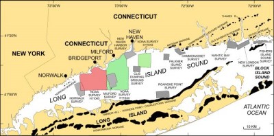
Sidescan-Sonar Imagery and Surficial Geologic Interpretation of the Sea Floor off Bridgeport, Connecticut

Map showing location of the Bridgeport, Connecticut study area.
Map showing location of the Bridgeport, Connecticut study area (red polygon). Click for larger image.

Collaborators:

NOAA logo with link to NOAA home page.Connecticut Dept. Environmental Protection Logo with link to CDEP Home page.

By 1E. Beaulieu, 1L.J. Poppe, 1V.F. Paskevich, 2E.F. Doran, 3B.E. Chauveau, 3J.M. Crocker, 4A.L. Beaver, and 3P.T. Schattgen

1Coastal and Marine Geology Program, U.S. Geological Survey, Woods Hole, MA 02543
2Long Island Sound Resource Center, Connecticut Department of Environmental Protection, Avery Point, Groton, CT 06340
3Atlantic Hydrographic Branch, National Oceanic and Atmospheric Administration, Norfolk, VA 23510
4National Oceanic and Atmospheric Administration, Narragansett, RI 02882

U.S. Geological Survey Open-file Report 2005-1162

2005

Any use of trade names is for descriptive purposes only and does not imply endorsement by the U.S. Government.


Skip past footer information

U.S. Department of Interior
> U.S. Geological Survey > Coastal and Marine Geology Program > Woods Hole Science Center

Disclaimer and Accessibility