 |
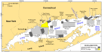
Figure 1. Map showing location of the interpolated bathymetry from the northern part of National Oceanic and Atmospheric Administration (NOAA) survey H11044 (yellow polygon). Sidescan-sonar imagery from this survey was interpreted by McMullen and others (2005); bathymetry from the southern part of this survey was interpolated and released by Poppe and others (2006a). Also shown are the sites of other NOAA bathymetric surveys (light gray polygons) and U.S. Geological Survey/Connecticut Department of Environmental Protection (USGS/CT-DEP) sidescan-sonar surveys (dark gray polygons) in Long Island Sound. Multibeam surveys: H11250 -- Poppe and others (2006b, 2007a); H11255 -- Poppe and others (2006c); H11252/H11361 -- Poppe and others (2007b, 2008). Sidescan-sonar surveys: Norwalk -- Twichell and others (1997); Milford -- Twichell and others (1998); New Haven harbor and CLIS dumping grounds -- Poppe and others (2001); Roanoke Point -- Poppe and others (1999a); Falkner Island -- Poppe and others (1999b); Hammonasset -- Poppe and others (1997); Niantic Bay -- Poppe and others (1998a); New London -- Zajac and others (2000, 2003); Fishers Island Sound -- Poppe and others (1998b); H11043 -- Poppe and others (2004); H11045 -- Beaulieu and others (2005). |
 |
Figure 2. A portion of the 1-m contoured bathymetry from DiGiacomo-Cohen and others (1998) showing the bathymetry within the boundary of NOAA survey H11044 off Milford, Connecticut. Image also shows the locations of the detailed views from figs. 8, 9, 10, and 11, and the axis of the elongate bathymetric high. |
 |
Figure 3. Image shows a port-side view of the National Oceanic and Atmospheric Administration (NOAA) Ship Rude, which carried out survey H11044 in north-central Long Island Sound. Image from NOAA. |
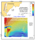 |
Figure 4. Image showing the original uninterpolated reconnaissance multibeam bathymetry from the southern part of National Oceanic and Atmospheric Administration survey H11044 in north-central Long Island Sound off Milford, Connecticut. |
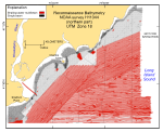 |
Figure 5. Image shows sea-floor coverage by the original uninterpolated reconnaissance single-beam (black) and shallow-water multibeam (red) bathymetry from the northern part of National Oceanic and Atmospheric Administration survey H11044 in north-central Long Island Sound off Milford, Connecticut. |
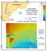 |
Figure 6. Image showing the interpolated and regridded multibeam bathymetry from the southern part of National Oceanic and Atmospheric Administration survey H11044 in north-central Long Island Sound off Milford, Connecticut. Sun illumination (that is, hill shading) is from the west. Hot colors represent shallower depths; cool colors represent deeper waters. |
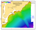 |
Figure 7. Image showing the interpolated and regridded multibeam bathymetry from the northern part of National Oceanic and Atmospheric Administration survey H11044 in north-central Long Island Sound off Milford, Connecticut. Sun illumination is from the northeast; vertical exaggeration is 8X. Hot colors represent shallower depths; cool colors represent deeper waters. |
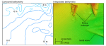 |
Figure 8. Detailed views of the contoured (left) and interpolated (right) bathymetry from National Oceanic and Atmospheric Administration survey H11044 south of Charles Island. Note the improved resolution of the rocky outcrops in the interpolated image. Location of view is shown in figure 2. |
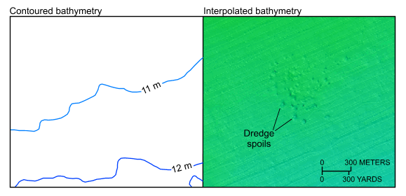 |
Figure 9. Detailed views of the contoured (left) and interpolated (right) bathymetry from National Oceanic and Atmospheric Administration survey H11044. Note the improved resolution of the dump site in the interpolated image. Location of view is shown in figure 2.
|
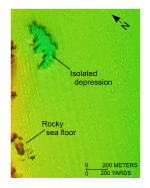 |
Figure 10. Detailed view of the interpolated bathymetry from the northern part of National Oceanic and Atmospheric Administration survey H11044. Image shows the rocky nature of the nearshore sea floor and one of the isolated depressions of unknown origin. Location of view is shown in figure 2. |
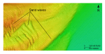 |
Figure 11. Detailed view of the interpolated bathymetry from the northern part of National Oceanic and Atmospheric Administration survey H11044. Image shows the variety of sand-wave morphologies off Stratford Point. Location of view is shown in figure 2. |


