Woods Hole Science Center
Interpolation of Reconnaissance Multibeam and Single-Beam Bathymetry Offshore of Milford, Connecticut
|
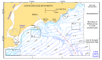
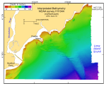
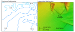
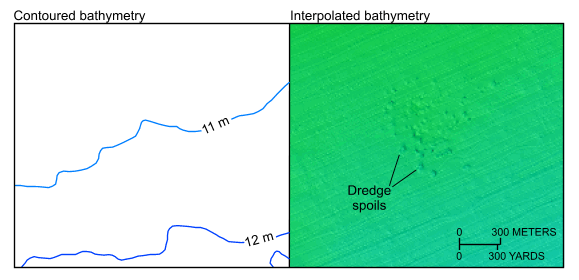
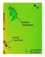
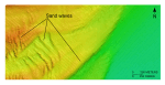
The interpolated bathymetric data from the northern part of survey H11044 are presented in figure 7. This hill-shaded image provides a topographic perspective that allows interpretation of features and processes of smaller scale than those in previously published bathymetric data sets. For example, although rocky outcrops off Charles Island are unrecognizable in the previously published contour data, they are clearly resolved by the interpolated grid of the dense single-beam bathymetric coverage (figs. 2, 8). Similarly, a dump site in the northeastern part of the study area cannot be identified in the contoured data, but is resolved in the grid of the shallow-water multibeam data (fig. 9). Most of the sea floor within the study area slopes gently to the southeast at a gradient of less than 1:200. Water depths in the study area are shallowest near the Connecticut coastline and deepest in the southeastern corner of the study area, ranging from less than 0.7 m to more than 21.5 m. The most conspicuous sea-floor feature in this data set is the elongate bathymetric high that extends seaward toward the southeast from the Connecticut coastline (figs. 2, 7). This feature, which progressively narrows seaward from a width of over 2500 m to less than 900 m along the southern border of the study area, is steeper on its southwestern flank and ranges from 1.2 to 3.3 m in relief. Earlier work based on high-resolution seismic-reflection profiles (Lewis and DiGiacomo-Cohen, 2000; Stone and others, 2005) showed that this feature is a submerged ice-marginal lacustrine fan deposit composed of proximal facies. Rocky outcrops are common along the coastline. They are around Charles Island and just offshore of the promontories to the east, notably Welches and Pond Points (figs. 8, 10). Although some of these outcrops may be bouldery accumulations associated with moraines (Stone and others, 2005), most are undoubtedly bedrock because they follow the onshore bedrock trends (Fritts, 1965). Also in the shallow waters along the coastline are several isolated depressions of unknown origin. These depressions have relatively flat floors with steep sides, 1 to 2 m of height above the surrounding seafloor, and long axes that exceed 500 m. Sand waves in two distinct morphologies are in the southwestern part of the data set around Stratford Point (fig. 11). The larger of these bedforms tends to have crestlines that parallel the bathymetry, amplitudes of 1.5 to 4 m, and typically steeper flanks on the seaward sides. The smaller sand waves are asymmetrical with the steeper flanks facing west (stoss slopes oriented toward the east) and have crestlines that are oriented more north-south, amplitudes of 0.7 to 0.8 m, and wavelengths of 50 to 200 m. Sand waves are also along the northern flanks of the elongate bathymetric high described above. Anthropogenic artifacts are also discernable in the bathymetry. These features include the entrance channel to the Housatonic River, which is dredged to over 6 m, and disposal mounds that are part of a small (less than 1 km wide) discontinued dumping ground centered around 41°11.4'N, 72°58.8'W (fig. 9). |