Woods Hole Science Center
Interpolation of Reconnaissance Multibeam and Single-Beam Bathymetry Offshore of Milford, Connecticut
|
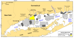
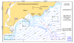
This report releases a set of newly available bathymetric data from the northern approximately 153-km² part of National Oceanic and Atmospheric Administration (NOAA) survey H11044 in north-central Long Island Sound (fig. 1), a major East Coast estuary surrounded by the most densely populated region of the United States. These new data have been interpolated and regridded into complete-coverage digital terrain models and imagery of the sea floor to supplement an earlier release by Poppe and others (2006) of interpolated and regridded bathymetry data from the southern section of NOAA survey H11044. McMullen and others (2005) includes a geologic interpretation of the sea floor in the entire survey area. The U.S. Geological Survey (USGS), in cooperation with NOAA and the Connecticut Department of Environmental Protection (CT DEP), is producing detailed maps of the sea floor in Long Island Sound. The current phase of this cooperative research program is directed toward studies of sea-floor topography and its effect on the distributions of sedimentary environments and benthic communities. Because anthropogenic wastes, toxic chemicals, and changes in land-use patterns resulting from residential, commercial, and recreational development have stressed the environment of the Sound, and caused degradation and potential loss of benthic habitats (Koppelman and others, 1976; Long Island Sound Study, 1994), detailed maps of the sea floor are needed to evaluate the extent of adverse impacts and to manage resources wisely in the future. Prior to our work, two digital regional bathymetric data sets were available for the Long Island Sound basin, a 1-m contour coverage (DiGiacomo-Cohen and others, 1998) (fig. 2) and a 3 arc-second topographic grid (Signell and Farris, 1998) based on NOAA's Coastal Relief Model (Divins and Metzger, 2008) and constructed for use in circulation and modeling studies (Signell and others, 2000). Whereas these data sets were good for general overviews, unfortunately neither of them includes enough detail to meet current research and management requirements. |