Woods Hole Science Center
Interpolation of Reconnaissance Multibeam and Single-Beam Bathymetry Offshore of Milford, Connecticut
|
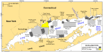
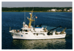
The bathymetric data and imagery in this report were produced from data collected during 2001 as part of NOAA hydrographic survey H11044 aboard the NOAA Ship Rude (fig. 1, fig. 3). A Reson SeaBat 9003 echosounder, which operates at 455 kHz, was used to acquire the shallow-water multibeam bathymetric data, and an Odom Echotrac DF-3200 dual-frequency echosounder was used to acquire the single-beam bathymetry data from the NOAA Ship Rude. An Odom Echotrac DF-3200 dual-frequency echosounder hull-mounted on a 23-ft launch deployed from the NOAA Ship Rude was used to acquire sounding data in the shallower areas. The multibeam data were acquired in XTF (extended Triton data format) and recorded digitally through an ISIS-data acquisition system. The bathymetric data were processed by using CARIS HIPS (Computer Aided Resource Information System Hydrographic Image Processing System) software for quality control and incorporation of sound-velocity and tidal corrections. Sound-velocity corrections were derived by using frequent Seabird SBE-19 CTD (conductivity-temperature-depth) profiles. Typically, a CTD cast was conducted once every four to six hours during bathymetry-data acquisition. Tidal-zone corrections were calculated from data acquired at tidal gauges at Bridgeport and New Haven, Connecticut, and at Kings Point, New York. The vertical resolution of the shallow-water multibeam data is approximately 0.5 percent of the water depth. The data were gridded to a 1.5-m resolution and exported in text (.txt) format. The vertical datum is mean lower low water; X and Y units are decimal degrees. For a more complete discussion of the acquisition methods, readers are encouraged to consult the original descriptive report (National Oceanic and Atmospheric Administration, 2001). The original processed bathymetric data set, which was provided by NOAA in ASCII comma-delimited text, did not entirely cover the sea floor because line spacing during acquisition left areas of no data in many places between the ship's tracks. Therefore, to provide a more continuous coverage, interpolation and gridding were done at the Woods Hole Science Center. The PROJ v 4.5 cartographic-projections library was used to project the data to Universal Transverse Mercator (UTM) zone 18 (Table 1A). A series of GMT (Generic Mapping Tools) v 4.0, including Minmax, were run during this process to determine the data bounds and to identify anomalous values (Table 1B), and an AWK script was run to filter the data set and prepare it to be processed through the GMT block-median routine (Table 1C). GMT v 4.0 programs were also used to create a 10-m interpolated GMT grid of the bathymetry. Interpolation was achieved during GMT processing by running the data through a block-median filter (Table 1D), a surface-generating algorithm (Table 1E), and the grid-cut program (Table 1F). The GDAL (Geospatial Data Abstraction Library) v 1.3.2 command-line utility “gdal_translate” was used to convert the GMT grid into a 32-bit GeoTIFF with proper bounds and projection information (Table 1G), and the GeoTIFF created in GMT/GDAL was then clipped by a shapefile of the survey area by using ESRI ArcGIS ArcToolbox v 9.2. The bathymetric grid was imported into IVS Fledermaus-DMagic v 6.5.1, and a hill-shade file was created with a 45-degree azimuth and an 8X vertical exaggeration. The hill-shade file was opened in IVS Fledermaus-ImageViewer v 6.5.1, projected, and exported as a GeoTIFF with a world file with an upper left origin. For a more detailed description of these processing methods, users should consult the metadata. The bathymetric grids and imagery released in this report should not be used for navigation. The browse graphics in this report are relatively small (less than 650 pixels wide) and of necessarily low resolution (about 72 dpi). GeoTIFF imagery or grid files at higher resolution may be downloaded from the Data Catalog section of the report and imported into a GIS application. GeoTIFF files may also be viewed directly by using a graphics application such as Corel Draw or Adobe Photoshop. Table 1. Scripts used to reprocess the bathymetry and to create the interpolated and regridded data sets in this report.
|