USGS - science for a changing world

USGS Coastal and Marine Geology Program
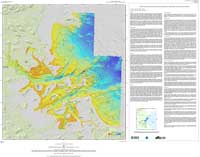
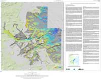
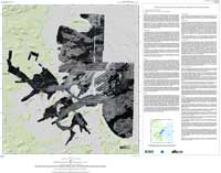
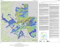
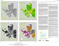
High-Resolution Geologic Mapping of the Inner Continental Shelf: Boston Harbor and Approaches, Massachusetts

Skip past Table of Contents to main text
Title Page
Table of Contents
List of Figures
Section 1
Introduction
Section 2
Maps
Section 3
Data Collection
and Processing
Section 4
Discussion
References
Acknowledgments
Appendix 1
Geographic
Information
System
Appendix 2
Sediment
Texture
Appendix 3
Bottom
Photographs

Section 2 - Maps

Five maps have been compiled showing the sea floor of Boston Harbor and Approaches.  Text on the map sheets briefly describes the data and methodologies, and summarizes key geomorphic features. Section 3 (Data Collection and Processing) and Section 4 (Discussion) in this report provide additional information to that presented on the map sheets.  Links to the map text and the map sheets are provided below.  The text is the same on all map sheets.


Map Sheet 1 (PDF): Shaded-relief topography of sea floor (colored by water depth)
Map (page size PDF)

Map Sheet 1.
Map Sheet 2 (PDF): Shaded-relief topography of sea floor (gray scale)
Map (page size PDF)


Map Sheet 2.
Map Sheet 3 (PDF): Backscatter intensity of sea floor (gray scale)
Map (page size PDF)


Map Sheet 3.
Map Sheet 4 (PDF): Shaded-relief topography of sea floor (colored by backscatter intensity)
Map (page size PDF)


Map Sheet 4.
Map Sheet 5 (PDF): Descriptive map of the sea floor geology
Map (page size PDF)


Map Sheet 5.


arrow left  Back to Section 1      arrow up  To Top of Page      arrow rightForward to Next Section  


Adobe Reader To view files in PDF format, download free copy of Adobe Reader.

Skip Navigation

Accessibility FOIA Privacy Policies and Notices

U.S. Department of the Interior | U.S. Geological Survey | Coastal and Marine Geology

URL: cmgds.marine.usgs.gov/publications/of2006-1008/html/maps.html
Page Contact Information: CMGDS Team
Page Last Modified: Wednesday, 06-Dec-2017 12:55:27 EST