
The multibeam echosounder (fig. 19) and sidescan sonar (fig. 20) data collected from Quicks Hole can be displayed as grids and images of the sea floor which provide detailed information on benthic character and, when combined with the subbottom seismic-profile and verification data, can be used to interpret the surficial geology (fig. 21).
Multibeam Bathymetry
Surveyed depths within the study area range from less than 3 m to almost 40 m (fig. 19). The shallowest areas occur along the shorelines of Pasque and Nashawena Islands, along an elongate shoal that extends northward from the passage between the islands, and on isolated bathymetric highs in the northern part of the study area. Numerous individual, rounded, bathymetric highs are scattered across these shallow areas and within the passage. These features, which give the sea floor in these areas a rough appearance, are interpreted to be boulders (fig. 22, fig. 23, and fig. 24). Although the boulders average 1-5 m in width, the largest exceeds 11 m across (fig. 25). These rocky areas are lag deposits remaining from the winnowed sediments of the Buzzards Bay moraine (fig. 21).
Depressions, presumably formed and maintained by intense tidal scour, surround the northern bathymetric highs. One of these scour depressions, a northeast-trending oval feature that lies along the eastern side of the elongate shoal, is the deepest spot in the study area, exceeding 39 m in depth. South of Quicks Hole in Vineyard Sound the sea floor slopes gently, but unevenly to the southeast. Most of the benthic complexity in this part of the study area consists of the alternating narrow elongate bathymetric highs and lows revealing the crests and troughs of adjacent sand waves (fig. 19). Crests of the sand waves are oriented variably northwest to northeast; amplitudes of the larger of these bedforms exceed 8 m. The deepest part of the study area south of Quicks Hole lies in a sand-wave trough near the southeastern corner, and exceeds 33 m deep.
Sidescan Sonar Backscatter
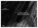
Distinctive tonal patterns revealed on the sidescan sonar mosaic (fig. 20) include: (1) complex patches of high and low backscatter with individual high-backscatter targets (objects), (2) areas of relatively high backscatter (light tones), (3) areas of relatively low backscatter (dark tones), and (4) alternating bands of high and low backscatter in a "tiger-stripe" pattern. Boundaries between patterns are commonly gradational; backscatter is not uniform throughout these areas. Water-column phenomena, such as turbulence around obstructions on the bottom, are also present on the image.
The complex patches of high and low backscatter with individual high-backscatter targets delineate the rocky, bouldery areas of the Buzzards Bay moraine (figs. 21 and fig. 26). Rocky areas are concentrated along shorelines around Pasque and Nashawena Islands, in Quicks Hole, and across the north-central part of the study area. Areas characterized by relatively high backscatter are concentrated adjacent to the bouldery deposits and on the crests of bathymetric highs. The higher backscatter tends to be produced by coarser-grained sediments, typically gravel and gravelly sand. Patches characterized by relatively low backscatter (fig. 21 and fig. 26) occur north of Pasque and Nashawena Islands in Buzzards Bay. These areas coincide with lower energy environments that form in the lee of the islands where they are protected from the prevailing southwesterly winds. The lower backscatter tends to be produced by finer grained Holocene marine sediment, typically clayey silt. Areas characterized by alternating bands of high and low backscatter include most of the southern part of the study area in Vineyard Sound and small isolated patches in the north-central part of the study area. This "tiger-stripe" pattern (fig. 20, fig. 21, and fig. 27), which is produced by sand waves, results from a combination of topographic changes affecting the angle of incidence of the sidescan sonar and the differences in sediment texture commonly present between crests and troughs of sand waves (Reineck and Singh, 1980).
|
Click on figures for larger images.
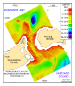 |
Figure 19. Digital terrain model (DTM) of the sea floor produced from multibeam bathymetry collected during NOAA survey H11076 of Quicks Hole, Massachusetts.
|
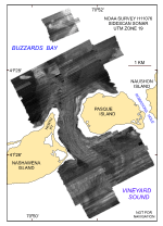 |
Figure 20. Map showing the sidescan sonar imagery produced from data collected during NOAA survey H11076 of Quicks Hole, Massachusetts.
|
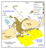 |
| Figure 21. Interpretation of the DTM and sidescan sonar mosaic from NOAA survey H11076 of Quicks Hole. Shown are the areas characterized by moraine, sand waves, and low backscatter. |
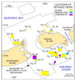 | | Figure 22. Map showing the boundary of the acoustic data from NOAA survey H11076 of Quicks Hole and the locations of the detailed planar, perspective, and comparative views of the multibeam DTM and sidescan sonar mocaic shown in other figures. |
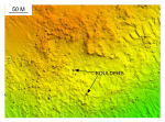 | | Figure 23. Detailed planar view of the bouldery sea floor south of Fox Point on Nashawena Island from the DTM produced during NOAA survey H11076. |
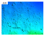 | | Figure 24. Detailed planar view of the bouldery sea floor north of Pasque Island from the DTM produced during NOAA survey H11076. |
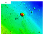 | | Figure 25. Detailed planar view of the bouldery sea floor on the elongate bathymetric high extending north of Quicks Hole. |
 | | Figure 26. Detailed planar view of the sidescan sonar mosaic from north of Nashawena Island showing representative backscatter tones. |
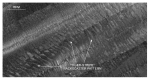 | | Figure 27. Detailed planar view of the sidescan sonar mosaic from north of Nashawena Island showing alternating bands of high and low backscatter ("tiger-stripe") pattern indicative of sand waves. |
|


