Skip USGS links group
U.S. Geological Survey - science for a changing world
NOAA logo with link to NOAA home page >CZM logo with link to CZM home page

Woods Hole Science Center

End of USGS links group
U.S. Geological Survey Open-File Report 2006-1357

Sea-Floor Character and Surface Processes in the Vicinity of Quicks Hole, Elizabeth Islands, Massachusetts


Bottom Photographs

Skip past contents information
Title Page
Introduction
Setting
Methods
Overview
Interpretation
Discussion
Data Catalog
Acknowledgments
References
List of Figures
Bottom Photographs
Sediment Data
Contacts
Disclaimers
Figure 14.  Map showing the station locations used to verify the acoustic data with bottom sampling and photography during the RAFAEL 05007 cruise.
Figure 14. Map showing the station locations used to verify the acoustic data with bottom sampling and photography during the RAFAEL 05007 cruise.

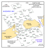
A total of 232 bottom photographs were obtained at 63 locations as part of this study (fig. 14). The small SEABOSS system was used to obtain 1-7 still photographs at each station as the RV Rafael drifted over the sea floor for 2-5 minutes. The field of view of each image is approximately 50 cm wide (photographs taken with small SEABOSS suspended about 50 cm above the bottom).

Low-resolution images (150 pixels wide) of the photographs may be viewed by browsing the thumbnails in the photo gallery below. These thumbnails are hyperlinked to medium-resolution images (550 pixels wide) for more detailed viewing. Alternatively, the directory containing the full-resolution images may be accessed by clicking here. These full-resolution images can be identified using the .jpg image names in galleries below. Texture analyses of samples obtained at these stations, where available, are provided in Sediment Data.

Photo Galleries

      Stations 1-20

      Stations 21-42

      Stations 43-63

Skip Navigation

Accessibility FOIA Privacy Policies and Notices

U.S. Department of the Interior | U.S. Geological Survey | Coastal and Marine Geology

URL: cmgds.marine.usgs.gov/publications/of2006-1357/html/bottomphoto1.html
Page Contact Information: CMGDS Team
Page Last Modified: Wednesday, 06-Dec-2017 13:03:35 EST