Woods Hole Science Center
Sea-Floor Character and Sedimentary Processes in the Vicinity of Woods Hole, Massachusetts
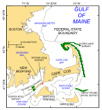
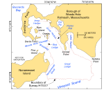
The digital terrain models (DTMs), imagery, interpretive data layers, and data presented herein were derived from multibeam echo-sounder and sidescan-sonar data collected in the vicinity of Woods Hole, the main passage between Buzzards Bay and Vineyard Sound, Massachusetts, and from the stations occupied to verify these acoustic data (fig. 1). Basic data layers show sea-floor topography, sun-illuminated shaded relief, and backscatter intensity; interpretive layers show the distributions of surficial sediment, sedimentary environments, and sea-floor features. Presented verification data include sediment grain-size analyses and a gallery of still photographs of the seabed. The multibeam and sidescan-sonar data, which together cover an approximately 2.5-km² area of sea floor, were collected during 2001 as part of National Oceanic and Atmospheric Administration (NOAA) hydrographic survey H11077 (figs. 1, 2). Although originally collected for hydrographic charting purposes, these data provide a fundamental framework for research and management activities along this part of the Massachusetts coastline (Noji and others, 2004), by showing the composition and terrain of the seabed, and providing information on sediment transport and benthic habitat. This publication is the fourth in a series of digital reports describing the sea-floor geology around Cape Cod (fig. 1). The first focused on the area off the eastern shore of the outer Cape (Poppe and others, 2006); the second on Quicks Hole, another passage through the Elizabeth Islands (Poppe and others, 2007a); and the third on Great Round Shoal Channel at the eastern entrance to Nantucket Sound (Poppe and others, 2007b). |
Click on figures for larger images.
|