Woods Hole Science Center
Sea-Floor Character and Sedimentary Processes in the Vicinity of Woods Hole, Massachusetts
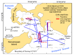
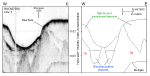
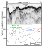
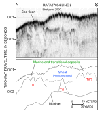
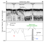
The seismic profiles acquired during the 2007 Research Vessel Rafael cruise RAFA07034 (fig. 11) provide insights into the stratigraphic framework and Quaternary geologic history of the Woods Hole sea floor. Three sedimentary units are inferred from the subbottom profiles: glacial moraine deposits of Pleistocene age, glaciolacustrine deposits of late Pleistocene age, and transitional and marine deposits of Holocene age. Although not resolved by our shallow high-resolution seismics, these deposits overlie a bedrock surface reported to be composed of gray to pink granodiorite at approximately 85 m below sea level (Hallett and others, 2004). Unstratified drift of the Buzzards Bay moraine, which underlies most of the study area, has an irregular, abrupt upper surface that forms an acoustic basement (fig. 29). Scattered on the moraine surface are many small (1-2 m) elevations interpreted to be boulders, and several large, relatively steep-sided, isolated depressions. A seismic facies characterized by finely laminated, rhythmic, parallel internal reflectors that drape the underlying topography can be seen within some of the depressions (fig. 29). On the basis of their seismic character, we interpret these deposits to be varved, muddy glaciolacustrine sediments. Intense tidal scour has restricted the deposition of modern marine sediments across much of the study area. Where present, these sediments are relatively thin or generally limited to more protected areas, such as the inner parts of Great and Little Harbors. Exceptions include the shoals located both east and west of Great Ledge. If compressional-wave velocities for unconsolidated sand are assumed to be 1600-1700 m/s, the Holocene sediments that comprise the shoal overlying the glacial and transitional deposits west of Great Ledge have an average thickness of 5.0 to 6.6 m (figs. 30, 31). However, the Holocene section in the shoal east of Great Ledge averages only about 2.5 m thick. The seismic signal in the inner part of Little Harbor is attenuated within small patches by the presence of gas (fig. 32). This gas is probably biogenic methane released from marsh or organic-rich estuarine deposits that are now buried by modern marine sediment. The seismic profiles collected during cruise RAFA07034 (fig. 11) can be accessed through the tabular data listing below. To view the seismic-reflection profiles through the data listing, click on the name of the preview image to display a down-sampled 'GIF' image of that seismic line. The image will be displayed in a new browser window. All preview images have been reduced to 72 dpi and a maximum width of 650 pixels for optimum viewing with a Web browser. Because the original size of the preview images varied, the images do not have the same scale. To access a full-resolution image of a seismic profile in ‘JPEG' format or the seismic data in 'SEG-Y' format, the user is advised to download the desired file, exit their browser, and open the file in an appropriate application (such as Corel Draw or Adobe Illustrator for a JPEG file). Instructions for downloading the full-resolution images follow the data listing.
Downloading with Microsoft Internet Explorer To download a data file while using Microsoft Internet Explorer, the user should select the desired file by placing the system pointer on the file name in the data list and pressing the right mouse button. This will display a pull-down menu from which the user should drag the mouse to highlight "Save target as ..." and release the mouse button. Internet Explorer will then prompt the user to specify the name and location where the selected data file should be saved.
|
Click on figures for larger images.
|