Woods Hole Science Center
Sea-Floor Character and Sedimentary Processes in the Vicinity of Woods Hole, Massachusetts
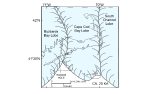
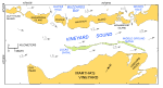
The geology of Cape Cod and the adjacent islands is a product of glacial processes during the late Pleistocene Epoch and a storm- and tidally dominated marine regime during the Holocene sea-level rise. The late Wisconsinan Laurentide ice sheet reached its maximum extent and southernmost position about 20 thousand years ago, as marked by terminal moraines on Block Island, Martha's Vineyard, and Nantucket and the southern limit of abundant gravel on the intervening sea floor (Schlee and Pratt, 1970; Oldale, 2001; Uchupi and others, 1996; fig. 3). This lobate ice front was formed by the Buzzards Bay lobe that deposited the moraine along the western part of Martha's Vineyard, the Cape Cod Bay lobe that deposited the moraines across eastern Martha's Vineyard and Nantucket, and the South Channel lobe that extended east toward Georges Bank (Oldale and Barlow, 1986; Oldale, 2001). A series of recessional moraines lie north of the terminal moraine on Martha's Vineyard. One of these recessional moraines, the Lucas moraine, occupies a position along the axis of Vineyard Sound marked by Lucas and Middle Ground Shoals (Smith, 1969; fig. 4). Shortly prior to 18 thousand years ago, the ice sheet had retreated and left the Buzzards Bay lobe along the Elizabeth Islands, the Cape Cod Bay lobe along the northern edge of Cape Cod, and the Great South Channel lobe just north of Great South Channel (Larson, 1982; Uchupi and others, 1996; fig. 5). The concave northward arc of the Elizabeth Islands and the moraine along the eastern side of Buzzards Bay record a minor re-advance during this lobe's retreat (Oldale and O'Hara, 1984; Oldale, 2001). Also about this time, the main part of Cape Cod was deposited as the Barnstable outwash plain, and a glacial lake occupied Nantucket Sound. The rate of the lobes' retreat varied. Deposits associated with the Buzzards Bay lobe are oldest; deposits associated with the Great South Channel lobe are youngest (Oldale and O'Hara, 1984; Oldale, 2001). Just after 18 thousand years ago, continued retreat of the ice fronts positioned the Buzzards Bay lobe northwest of Buzzards Bay, the Cape Cod Bay lobe in Cape Cod Bay, and the Great South Channel lobe northward and eastward (Uchupi and others, 1996). Prior to sea-level rise, the glacial drift was eroded by streams that flowed southward and southeastward toward present-day Vineyard Sound. During Holocene submergence, the postglacial valleys were partly filled by estuarine and marsh deposits. Transgressing seas eroded and smoothed the sea floor. Marine sediments accumulated over the wave-cut surface. Shallow stratigraphy interpreted from high-resolution seismic profiles, collected as part of this and earlier studies (Robb and Oldale, 1977; O'Hara and Oldale, 1980), reflects this Quaternary history. The Holocene marine transgression submerged much of the offshore extension of the Buzzards Bay moraine. Topographic highs along this part of the moraine form the Elizabeth Islands, a 26-km-long chain of small islands that trends southwest from Cape Cod, which effectively separates Vineyard Sound from Buzzards Bay (fig. 4). Passages between the islands are locally called “holes.” Woods Hole is the passage between Nonamesset Island and Cape Cod. Strong tidal currents in the holes are driven by the different filling rates and sizes of the adjacent water bodies. Flood tide just south of Devils Foot Island in Woods Hole, which flows south from Buzzards Bay into Vineyard Sound, exceeds 4.1 knots (Eldridge, 2006; fig. 4). Ebb tides are slightly weaker, but exceed 3.9 knots. These currents have winnowed the till that composes the moraine, leaving local bouldery lag deposits on the sea floor. |
Click on figures for larger images.
|