 |
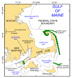
Figure 1. Index map of Cape Cod and southeastern Massachusetts showing location of the study area (red polygon). Also shown are the locations of earlier studies (Outer Cape Survey: Poppe and others, 2006; Quicks Hole Survey: Poppe and others, 2007a; Great Round Shoal Survey: Poppe and others, 2007b) completed as part of this series (green polygons).
|
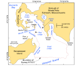 |
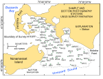
Figure 2. Index map of Woods Hole showing the boundary of the study area (red polygon) and local physiographic features.
|
 |
Figure 3. Regional paleogeographic map of Cape Cod and the Islands showing the extent of the Laurentide ice sheet about 20 thousand years ago. (Modified from Oldale and Barlow, 1986.) |
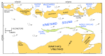 |
Figure 4. Map of Vineyard Sound showing the direction and maximum velocity (in knots) of the tidal flow during flood tide (Eldridge, 2006) and the locations of Woods and Quicks Holes and Lucas and Middle Ground Shoals. |
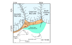 |
Figure 5. Regional paleogeographic map of Cape Cod and the Islands showing the extent of the Buzzards Bay, Cape Cod Bay, and South Channel lobes just prior to 18 thousand years ago and location of Glacial Lake Nantucket Sound. (Modified from Oldale and Barlow, 1986.) |
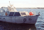 |
Figure 6.
Starboard-side view of National Oceanic and Atmospheric Administration (NOAA) Launch 1014 afloat. This hydrographic vessel was deployed from the NOAA Ship Whiting. |
 |
Figure 7. Port-side view of the National Oceanic and Atmospheric Administration Ship Whiting at sea. Note the 30-foot survey launches stowed on the aft sides of the ship ready for deployment.
|
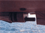 |
Figure 8. The Reson Seabat 8101 hull mounted in the keel cut out of National Oceanic and Atmospheric Administration Launch 1005.
|
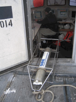 |
Figure 9. CTD (conductivity-temperature-depth) profiler. Data derived from frequent deployments of this device were used to perform sound-velocity corrections on the multibeam data.
|
 |
Figure 10. Port-side view of the U.S. Geological Survey Research Vessel Rafael that was used to take bottom photographs and collect sediment samples in Woods Hole, Massachusetts.
|
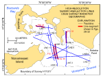 |
Figure 11. Map showing the locations of the tracklines (blue lines) along which the chirp high-resolution seismic-reflection data were collected during the November 2007 Rafael 07034 cruise and the locations of line segments shown in figures 29-32 (red segments). |
 | Figure 12. Map showing the locations of stations used to verify the acoustic data with bottom sampling and photography during the November 2007 Rafael 07034 cruise. |
 |
Figure 13. View of the small SEABOSS, a modified Van Veen grab sampler equipped with still and video photographic systems, mounted on the aft starboard side of the Research Vessel Rafael. Note the winch mounted on the davit (left) and the take-up reel for the video-signal and power cable (right).
|
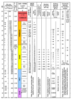 |
Figure 14. Correlation chart (Poppe and others, 2005) showing the relations among phi sizes, diameter in millimeters, size classifications (Wentworth, 1922), and American Society of Testing and Materials (ASTM) and Tyler sieve sizes. Chart also shows the corresponding intermediate diameters, grains per milligram, settling velocities, and threshold velocities for traction. |
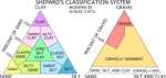 |
Figure 15. Sediment classification scheme from Shepard (1954), as modified by Schlee (1973). |
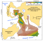 |
Figure 16. Digital terrain model (DTM) of the sea floor produced from multibeam bathymetry collected during National Oceanic and Atmospheric Administration survey H11077 of Woods Hole, Massachusetts. Image is sun-illuminated from the north and vertically exaggerated 5x. |
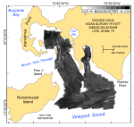 |
Figure 17. Map showing the sidescan-sonar imagery produced from data collected during National Oceanic and Atmospheric Administration survey H11077 of Woods Hole, Massachusetts. Hard returns (high backscatter) indicate generally coarser grained sediments; softer returns (low backscatter) indicate generally finer grained sediments. |
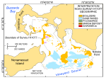 |
Figure 18. Interpretation of the digital terrain model and sidescan-sonar mosaic from National Oceanic and Atmospheric Administration survey H11077 of Woods Hole, Massachusetts. Shown are the areas characterized by boulders, sand waves, pockmarks, and marsh deposits. Also shown are the locations of shipwrecks. White areas within the study area are primarily reworked Holocene sediment. |
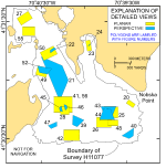 |
Figure 19. Map showing the boundary of the acoustic data from National Oceanic and Atmospheric Administration survey H11077 of Woods Hole, Massachusetts and the locations of the detailed planar (yellow polygons) and perspective (blue polygons) views of the multibeam digital terrain model and sidescan-sonar mosaic shown in indicated figures. |
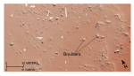 | Figure 20. Detailed planar view of the bouldery sea floor off Nobska Point from the digital terrain model produced during National Oceanic and Atmospheric Administration survey H11077 of Woods Hole, Massachusetts. Boulders rest on the winnowed upper surface of the submerged Buzzards Bay moraine. Location of view is shown in figure 19. |
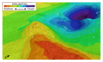 |
Figure 21. Detailed perspective view of the large depression northeast of Juniper Point from the digital terrain model produced during National Oceanic and Atmospheric Administration survey H11077 of Woods Hole, Massachusetts. Location of view is shown in figure 19. Shallower areas are warm colors; deeper areas are cooler colors. |
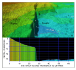 |
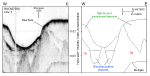
Figure 22. Detailed perspective view of the bathymetry looking south along the scarplet at the edge of Parker Flats from the digital terrain model produced during National Oceanic and Atmospheric Administration survey H11077 of Woods Hole, Massachusetts. Line shows location of transect; cross section shows scaled bathymetry. Location of view is shown in figure 19. |
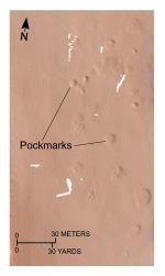 |
Figure 23. Detailed planar view of the depressions interpreted to be pockmarks from the digital terrain model produced during National Oceanic and Atmospheric Administration survey H11077 of Woods Hole, Massachusetts. Pockmark field is located at the northern end of Little Harbor; location of view is shown in figure 19. |
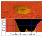 |
Figure 24. Detailed perspective view of a pockmark at the northern end of Little Harbor from the digital terrain model produced during National Oceanic and Atmospheric Administration survey H11077 of Woods Hole, Massachusetts. Line shows location of transect; cross section shows scaled bathymetry. Location of view is shown in figure 19. |
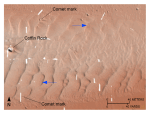 |
Figure 25. Detailed planar view of the transverse sand waves east of Great Ledge from the digital terrain model produced during National Oceanic and Atmospheric Administration survey H11077. Blue arrows show direction of net transport interpreted from sand-wave asymmetry. Note that scour around boulders forms comet marks and that boulders protrude through the sand and also the sharp transition to megaripples along the northern edge of the field. Location of view is shown in figure 19. |
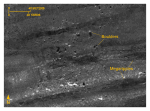 |
Figure 26. Detailed planar view southeast of Great Ledge of the sidescan-sonar mosaic produced during National Oceanic and Atmospheric Administration survey H11077 of Woods Hole, Massachusetts. View shows high-backscatter targets interpreted to be boulders. Note small patches of megaripples. Location of view is shown in figure 19. |
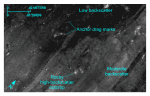 |
Figure 27. Detailed planar view from the Inner Harbor of the sidescan-sonar mosaic produced during National Oceanic and Atmospheric Administration survey H11077 of Woods Hole, Massachusetts, showing areas of relatively low backscatter and moderate backscatter. Note presence of anchor drag marks and high-backscatter objects interpreted to be rocks. Location of view is shown in figure 19. |
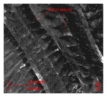 |
Figure 28. Detailed planar view of the sidescan-sonar mosaic produced during National Oceanic and Atmospheric Administration survey H11077 of Woods Hole, Massachusetts, showing relatively straight to sinuous alternating bands of high and low backscatter (“tiger-stripe”) pattern indicative of transverse sand waves. Location of view, which is in the channel west of Great Ledge, is shown in figure 19. |
 | Figure 29. Segment of chirp high-resolution seismic-reflection profile and interpretation from cruise RAFA07034 line 1 across a large, isolated depression in the Inner Harbor of Woods Hole. Note that till forms acoustic basement and that rhythmic reflectors record glaciolacustrine sedimentation. Location of profile is shown in figure 11. |
 | Figure 30. Segment of chirp high-resolution seismic-reflection profile and interpretation from cruise RAFA07034 line 10 across the shoal in the channel west of Great Ledge. Note that till forms acoustic basement and that the shoal is largely composed of Holocene sediment. Location of profile is shown in figure 11. |
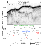 | Figure 31. Segment of chirp high-resolution seismic-reflection profile and interpretation from cruise RAFA07034 line 2 across the shoal in the channel west of Great Ledge. Note that till forms acoustic basement and that the shoal is largely composed of Holocene sediment. Location of profile is shown in figure 11. |
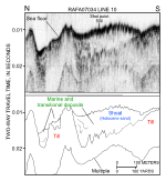
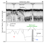 | Figure 32. Segment of chirp high-resolution seismic-reflection profile and interpretation from cruise RAFA07034 line 3 in Little Harbor. Note that biogenic gas within the marine and transitional deposits attenuates the seismic signal. Location of profile is shown in figure 11. |
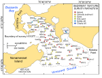 |
Figure 33. Map showing the station locations used to verify the acoustic data, color-coded for sediment texture. Hotter colors are coarser grained sediment; cooler colors are finer grained sediments. See key for sediment classifications. |
 | Figure 34. Bottom photographs from stations WH40 (left) and WH48 (right) showing boulders and gravel that armor the sea floor in areas with sedimentary environments characterized by the process of erosion or nondeposition. Station locations are shown in figure 12. |
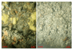
 | Figure 35. Bottom photographs from stations WH32 (left) and WH39 (right) showing the mussel beds that commonly cover boulders in high-energy environments. Station locations are shown in figure 12.
|
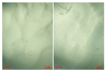 |
Figure 36. Bottom photographs from stations WH9 (left) and WH14 (right) showing current-rippled sand that is prevalent in areas characterized by sedimentary environments of coarse-bedload transport. Station locations are shown in figure 12. |
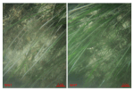 |
Figure 37. Bottom photographs from stations WH1 (left) and WH7 (right) showing the eelgrass beds that are prevalent in shallow areas and along shorelines. Station locations are shown in figure 12. |
 | Figure 38. Bottom photographs from stations WH27 (left) and WH56 (right) showing the muddy sediment, organic mats, and burrows that are prevalent in areas characterized by sedimentary environments of long-term deposition. Station locations are shown in figure 12.
|
 |
Figure 39. Detailed perspective view of the small, isolated elevations interpreted to be boulders on the southwestern flank of Great Ledge. Location of view is shown in figure 19.
|
 |
Figure 40. Detailed perspective view of the bathymetry in the southeastern part of the study area from the digital terrain model produced during National Oceanic and Atmospheric Administration survey H11077 of Woods Hole, Massachusetts. Note the abundance of boulders and small patches of rippled sand indicative of the exposed glacial drift and the thin, patchy nature of the Holocene deposits in this part of Vineyard Sound. Location of view is shown in figure 19. |
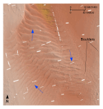 |
Figure 41. Detailed planar view of the transverse sand waves on the shoal west of Great Ledge from the digital terrain model produced during National Oceanic and Atmospheric Administration survey H11077. Blue arrows show direction of net transport interpreted from sand-wave asymmetry. Location of view is shown in figure 19. |
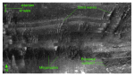 |
Figure 42. Detailed planar view along the southern edge of the sidescan-sonar mosaic produced during National Oceanic and Atmospheric Administration survey H11077 of Woods Hole, Massachusetts, showing relatively straight to sinuous alternating bands of high and low backscatter (“tiger-stripe”) pattern indicative of transverse sand waves. Note the abundance of megaripples between and on the stoss slopes of the waves indicative of active transport, and that the crest orientation of the sand waves and megaripples does not always match. Location of view is shown in figure 19. |
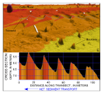 |
Figure 43. Detailed perspective view of the bathymetry looking north across the sand-wave field east of Great Ledge from the digital terrain model produced during National Oceanic and Atmospheric Administration survey H11077 of Woods Hole, Massachusetts. Line shows location of transect; cross section shows scaled bathymetry and that sand-wave asymmetry indicates net westward transport along the southern part of this sand-wave field. Location of view is shown in figure 19. |
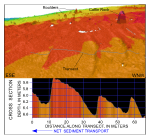 |
Figure 44. Detailed perspective view of the bathymetry looking south across the sand-wave field east of Great Ledge from the digital terrain model produced during National Oceanic and Atmospheric Administration survey H11077 of Woods Hole, Massachusetts. Line shows location of transect; cross section shows scaled bathymetry and that sand-wave asymmetry indicates net eastward transport along the northern part of this sand-wave field. Location of view is shown in figure 19. |
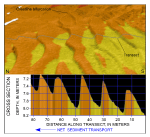 |
Figure 45. Detailed perspective view of the bathymetry looking east across the sand-wave field in the channel west of Great Ledge from the digital terrain model produced during National Oceanic and Atmospheric Administration survey H11077 of Woods Hole, Massachusetts. Line shows location of transect; cross section shows scaled bathymetry and that sand-wave asymmetry indicates net northward transport along the western side of this sand-wave field. Location of view is shown in figure 19. |
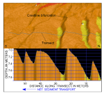 |
Figure 46. Detailed perspective view of the bathymetry looking west across the sand-wave field in the channel west of Great Ledge from the digital terrain model produced during National Oceanic and Atmospheric Administration survey H11077 of Woods Hole, Massachusetts. Line shows location of transect; cross section shows scaled bathymetry and that sand-wave asymmetry indicates net southward transport along the eastern side of this sand-wave field. Location of view is shown in figure 19. |
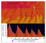 |
Figure 47. Detailed perspective view of the bathymetry looking north across the sand-wave field south of Nonamesset Shoal from the digital terrain model produced during National Oceanic and Atmospheric Administration survey H11077 of Woods Hole, Massachusetts. Line shows location of transect; cross section shows scaled bathymetry and that sand-wave asymmetry indicates net westward transport in this part of Vineyard Sound. Location of view is shown in figure 19. |
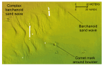 |
Figure 48. Detailed planar view of the barchanoid sand waves southeast of Great Ledge from the digital terrain model produced during National Oceanic and Atmospheric Administration survey H11077 of Woods Hole, Massachusetts. Note that wave orientation indicates net westward transport, and that the waves become more complex downcurrent. Location of view is shown in figure 19. |
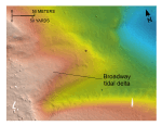 |
Figure 49. Detailed planar view of the digital terrain model produced during National Oceanic and Atmospheric Administration survey H11077 of Woods Hole, Massachusetts. Image shows the tidal delta at the eastern end of Broadway, a southeastward-trending passage in Woods Hole. Location of view is shown in figure 19. |
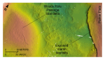 |
Figure 50. Detailed planar view of the digital terrain model produced during National Oceanic and Atmospheric Administration survey H11077 of Woods Hole, Massachusetts. Image shows the tidal delta at the eastern end of the Woods Hole Passage. Note the exposed marsh deposits that form the edge of Parker Flats. Location of view is shown in figure 19. |
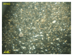 |
Figure 51. Bottom photograph from station WH43 at the eastern end of the Woods Hole Passage. Photo shows the dense mussel shellbeds that form part of the ebb-tidal delta. Station locations are shown in figure 12.
|
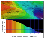 |
Figure 52. Detailed perspective view showing the tidal delta prograding from the eastern end of Broadway from the digital terrain model produced during National Oceanic and Atmospheric Administration survey H11077 of Woods Hole, Massachuestts. Line shows location of transect; cross section shows scaled bathymetry. Location of view is shown in figure 19. |
 |
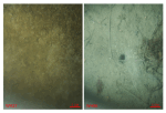
Figure 53. Bottom photograph from station WH61 showing the steep scarplet along the edge of Parker Flats. Bathymetry deepens toward the left; station location is shown in figure 12.
|
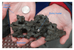 |
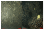
Figure 54. Photograph of a grab sample of marsh sediment from station WH61. Note the presence of fibrous organic matter and cavities formed by bio-erosion, one of which is occupied by a boring mussel. Quarter is provided for scale; station location is shown in figure 12.
|
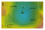 |
Figure 55. Detailed planar view of the digital terrain model produced during National Oceanic and Atmospheric Administration survey H11077 of Woods Hole, Massachusetts. Image shows four wrecks in a depression within the Inner Harbor. Location of view is shown in figure 19. |
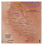 |
Figure 56. Detailed planar view of the shoal west of Great Ledge. Image shows the extent of the shoal (dashed lines) and vibracore stations. Numbers separated by vertical lines show mean lower low water depth and thickness of the shoal above the surrounding sea floor, respectively. Location of view is shown in figure 19. |


