
The multibeam-echosounder (fig. 16) and sidescan-sonar (fig. 17) data collected from Woods Hole displayed as grids and images of the sea floor, which provide detailed information on benthic character, combined with the subbottom seismic-profile and verification data are used to interpret the surficial geology (fig. 18).
Multibeam Bathymetry
Surveyed depths within the study area range from less than 3 m to almost 27 m (fig. 16). The shallowest areas are found along the shorelines and on isolated bathymetric highs such as Nonamesset Shoal. Many small, individual, rounded bathymetric highs are also scattered across these shallow areas, around Great Ledge, and on the sea floor in Vineyard Sound in the southeastern part of the study area. These features that give the sea floor in these areas a rough appearance are interpreted to be boulders (figs. 19, 20). Although the boulders average 1 to 5 m in width, the largest, known as Coffin Rock, exceeds 12 m across. These rocky areas are lag deposits remaining from the winnowed sediments of the Buzzards Bay moraine.
At least five large, isolated depressions (greater than 100 m in nominal diameter) are present in Great Harbor and within the Inner Harbor. One of these depressions (fig. 21), a complex northwest-trending elongate feature that lies west of Juniper Point, is the deepest spot in the study area, approaching 27 m in depth. Bathymetric changes throughout most of the study area are typically gradual. However, notably along the edge of Parker Flat, depth can change dramatically (fig. 22). In this area, relief is more than 5 m and the slope is nearly vertical in places.
Many smaller depressions, which we interpret to be pockmarks (see the Character and Processes section), are present at the northern end of Little Harbor (figs. 23, 24). These depressions average about 0.5 m deep and 7 m wide, but range up to 14 m in diameter. The morphology of the features is quite varied. Some are rounded, others are irregular; some are flat floored, others have a central peak; some have steep sides, whereas the sides of others slope more gently.
South of Woods Hole in Vineyard Sound, the sea floor slopes gently to the southeast. Most of the benthic complexity in this part of the study area consists of the alternating narrow elongate bathymetric highs and lows revealing the crests and troughs of adjacent sand waves (fig. 25). Crests of the sand waves in the Woods Hole channel between Nonamesset Shoal and Great Ledge trend roughly east-west. Elsewhere, crest orientation in the larger sand-wave fields varies from 315° to 45°, but averages north-south. Amplitudes of the larger of these bedforms exceed 1.5 m, and wavelengths can exceed 25 m.
Sidescan-Sonar Backscatter
Distinctive tonal patterns revealed on the sidescan-sonar mosaic (fig. 17) include (1) complex patches of high and low backscatter with individual high-backscatter targets (objects), (2) areas of relatively high backscatter (light tones), (3) areas of relatively low backscatter (dark tones), and (4) alternating bands of high and low backscatter in a “tiger-stripe” pattern. Boundaries between patterns are commonly gradational; backscatter is not uniform throughout these areas. Water-column phenomena, such as turbulence around obstructions on the bottom, are also present on the image.
The complex patches of high and low backscatter with individual high-backscatter targets delineate the rocky, bouldery areas of the Buzzards Bay moraine (fig. 26). Rocky areas are concentrated along shorelines, such as around Nobska and Juniper Points and Grassy Island, and around Great Ledge. Areas characterized by relatively high backscatter are concentrated adjacent to the bouldery deposits and on the crests of bathymetric highs. The higher backscatter tends to be produced by coarser grained sediments, typically gravel and gravelly sand, and reflects higher energy environments. Patches characterized by relatively low backscatter (fig. 27) are found at the northern end of Little Harbor and in the Inner Harbor formed by the convex side of Penzance Point. These areas coincide with lower energy environments that prevail in areas protected from the strong tidal- and storm-driven currents. The lower backscatter tends to be produced by finer grained Holocene marine sediments, typically silty sand and clayey silt.
Areas characterized by alternating bands of high and low backscatter include much of the southern part of the study area in Vineyard Sound and in the channel between Nonamesset Shoal and Great Ledge. This “tiger-stripe” pattern (fig. 28), which is produced by sand waves and megaripples, results from a combination of topographic changes affecting the angle of incidence of the sidescan sonar and the differences in sediment texture commonly present between crests and troughs of sand waves (Reineck and Singh, 1980). |
Click on figures for larger images.
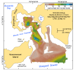 |
Figure 16. Digital terrain model (DTM) of the sea floor produced from multibeam bathymetry collected during National Oceanic and Atmospheric Administration survey H11077 of Woods Hole, Massachusetts.
|
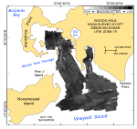 |
Figure 17. Map showing the sidescan-sonar imagery produced from data collected during National Oceanic and Atmospheric Administration survey H11077 of Woods Hole, Massachusetts.
|
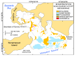 |
Figure 18. Interpretation of the digital terrain model and sidescan-sonar mosaic from National Oceanic and Atmospheric Administration survey H11077 of Woods Hole, Massachusetts.
|
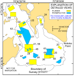 |
Figure 19. Map showing the boundary of the acoustic data from National Oceanic and Atmospheric Administration survey H11077 of Woods Hole, Massachusetts and the locations of the detailed planar (yellow polygons) and perspective (blue polygons) views of the multibeam digital terrain model and sidescan-sonar mosaic shown in indicated figures.
|
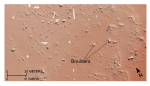 |
Figure 20. Detailed planar view of the bouldery sea floor off Nobska Point from the digital terrain model produced during National Oceanic and Atmospheric Administration survey H11077 of Woods Hole, Massachusetts.
|
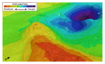 |
Figure 21. Detailed perspective view of the large depression northeast of Juniper Point from the digital terrain model produced during National Oceanic and Atmospheric Administration survey H11077 of Woods Hole, Massachusetts.
|
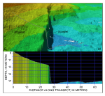 |
Figure 22. Detailed perspective view of the bathymetry looking south along the scarplet at the edge of Parker Flats from the digital terrain model produced during National Oceanic and Atmospheric Administration survey H11077 of Woods Hole, Massachusetts.
|
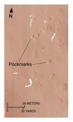 |
Figure 23. Detailed planar view of the depressions interpreted to be pockmarks from the digital terrain model produced during National Oceanic and Atmospheric Administration survey H11077 of Woods Hole, Massachusetts.
|
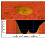 |
Figure 24. Detailed perspective view of a pockmark at the northern end of Little Harbor from the digital terrain model produced during National Oceanic and Atmospheric Administration survey H11077 of Woods Hole, Massachusetts.
|
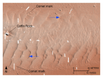 |
Figure 25. Detailed planar view of the transverse sand waves east of Great Ledge from the digital terrain model produced during National Oceanic and Atmospheric Administration survey H11077.
|
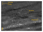 |
Figure 26. Detailed planar view southeast of Great Ledge of the sidescan-sonar mosaic produced during National Oceanic and Atmospheric Administration survey H11077 of Woods Hole, Massachusetts.
|
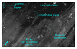 |
Figure 27. Detailed planar view from the Inner Harbor of the sidescan-sonar mosaic produced during National Oceanic and Atmospheric Administration survey H11077 of Woods Hole, Massachusetts, showing areas of relatively low backscatter and moderate backscatter.
|
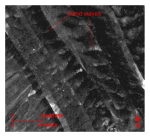 |
Figure 28. Detailed planar view of the sidescan-sonar mosaic produced during National Oceanic and Atmospheric Administration survey H11077 of Woods Hole, Massachusetts, showing relatively straight to sinuous alternating bands of high and low backscatter (“tiger-stripe”) pattern indicative of transverse sand waves.
|
|


