Imagenex Sonars
Two types of sonars made by Imagenex(http://www.imagenex.com/) have been used to document changes in the seafloor over time. Each sonar emits a pulse or beam of high frequency sound over the seafloor and the sound reflects off objects and topographic features. The length of time required for reflected sound to return to the sensor is used to map seafloor bedforms like sand waves and ripples. The 881A (fig. 22a) makes repeated linear scans perpendicular to the head. Actual heights of the seafloor along the scan can be computed from this sonar data. The 881 fan sonar (fig. 22b)samples many lines as it rotates through a pre-programmed arc, allowing a "snapshot" of the seafloor within 3 to 5 meters of the head to be created. Both sonars may be configured to collect a number of images over some duration which may be averaged to produce a single sonar image
Photographs
Some tripods have cameras mounted on them that obtain time-series photographs of the seafloor, typically every 4 or 6 hours. These photographs are not presently part of this digital database and are distributed in reports as needed (for example, see Butman and others, 2007).
| Click on figures for larger images.
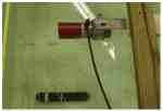
Figure 22A. An Imagenex 881A imaging sonar in a laboratory test tank. |
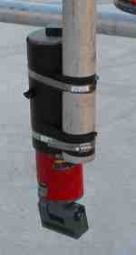
Figure 22B. An Imagenex 881 fan sonar. The gray part at the bottom of the sonar rotates and makes sequential images of the seafloor.
|
|