
|
A 95-kHz Simrad EM1002 multibeam system mounted on the hull of NOAA Ship Thomas Jefferson (fig. 3) was used to acquire over 560 km of survey lines from the deeper parts (>20 m water depth) of the study area during 2003. Two 29-foot launches with hull-mounted 455-kHz Reson 8125 and 240-kHz Reson 8101 systems acquired an additional 637 km of survey lines from shallower areas (fig. 4, fig. 5, fig. 6, and fig. 7).
The survey lines were generally run parallel to the bathymetry contours at a line spacing three to five times the water depth. Navigation was by differential GPS; Hypack MAX was used for acquisition line navigation. Sound velocity corrections were derived using frequent CTD (conductivity-temperature-depth) profiles (fig. 8). Typically, a CTD cast was conducted every four to six hours of multibeam acquisition. Tidal zone corrections were calculated from data acquired at primary and secondary tide-gauge stations using acoustic stilling-well gauges. Vertical datum is mean lower low water.
The multibeam data were acquired in XTF (extended Triton data format), recorded digitally through an ISIS data acquisition system, and processed using CARIS SIPS/HIPS (Sidescan Image Processing System / Hydrographic Image Processing System) software for quality control, to incorporate sound velocity and tidal corrections and to combine the Simrad abd Reson data to produce the continuous digital terrain model (DTM) shown in figure 9. Horizontal resolution of the data varies with water depth, but averages about 2 m. Vertical resolution is about 0.5% of the water depth.
A dual-frequency Knudsen 320BR 2-7 kHz Chirp and 200-kHz echosounder system collected high-resolution seismic-reflection subbottom profile data. This system used hull-mounted transducers, and recorded in SEG-Y digital format. Boomer data from two previous State of Connecticut/USGS seismic cruises (Needell and Lewis, 1984; Lewis and Needell, 1987; Poppe and others, 2002) aided in the geologic interpretation of the multibeam data.
|
Click on figures for larger images.
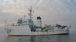 |
Figure 3. Port-side view of the NOAA Ship Thomas Jefferson at sea.
|
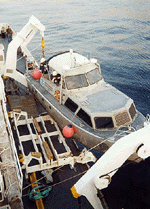 |
Figure 4. Image showing NOAA Launch 1014 being deployed from the NOAA Ship Thomas Jefferson.
|
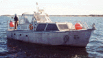 |
Figure 5. Image showing a starboard-side view of NOAA Launch 1014 afloat.
|
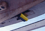 |
Figure 6. Image showing the Reason 8125 multibeam transducer mounted to the hull of the NOAA Launch 1014.
|
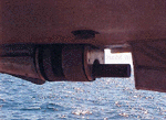 |
Figure 7. Image showing the Reason Seabat 8101 hull mounted in the keel cut out of NOAA Launch 1005.
|
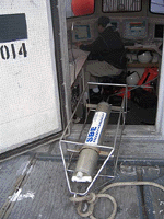 |
Figure 8. CTD (conductivity-temperature-depth) profiler shown on the deck of the NOAA Ship Thomas Jefferson.
|
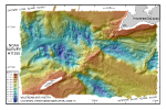 |
Figure 9. Digital terrain model (DTM) of the sea floor in eastern Long Island and western Block Island sounds produced from multibeam bathymetry data.
|
|


