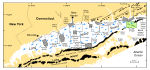
 | Figure 1. Map showing location of the study area (green polygon). Also shown are major onshore moraines, the sites of other interpreted multibeam and sidescan sonar surveys (USGS: shaded polygons; NOAA: open polygons), and a generalized circulation model (blue arrows; Welsh, 1993). |
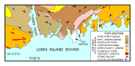 | Figure 2. Bedrock geologic map of the area onshore from NOAA survey H11250 simplified from Rodgers (1985). Image shows directions of glacial ice movement (blue arrows; Goldsmith, 1962) and the Avalonian anticlinorium.
|
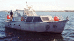
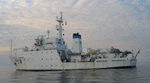 | Figure 3. Port-side view of the NOAA Ship Thomas Jefferson at sea. Note that the 30-foot survey launch normally stowed on this side of the ship has been deployed.
|
 | Figure 4. Image showing NOAA Launch 1014 being deployed from the NOAA Ship Thomas Jefferson.
|
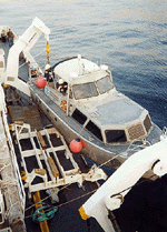
 | Figure 5. Image showing a starboard-side view of NOAA Launch 1014 afloat.
|
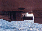
 | Figure 6. Image showing the Reason 8125 multibeam transducer mounted to the hull of the NOAA Launch 1014.
|
 | Figure 7. Image showing the Reason Seabat 8101 hull mounted in the keel cut out of NOAA Launch 1005.
|
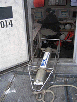 | Figure 8. CTD (conductivity-temperature-depth) profiler shown on the deck of the NOAA Ship Thomas Jefferson. Data derived from frequent deployments of this device were used to perform sound velocity corrections on the multibeam data.
|
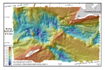 | Figure 9. Digital terrain model (DTM) of the sea floor in eastern Long Island and western Block Island sounds produced from multibeam bathymetry data. Image is sun-illuminated from the north, and vertically exaggerated 8X. Colors trending toward red are shallower areas, and those trending toward blue are deeper areas. See key for depth ranges.
|
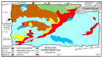 | Figure 10. Interpretation of the geological units on the DTM. Image shows extent of exposed moraine, bedrock, glaciolacustrine, deltaic, and coastal plain deposits. Also shown are the distributions of reworked sediment over glacial lake deposits, deltaic deposits pock-marked by the release of biogenic gas, and a drumlin.
|
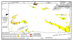 | Figure 11. Interpretation of the modern features on the DTM. Arrows show directions of net sediment transport, based on sand wave asymmetry. Also shown are the locations of barchanoid and transverse sand waves, dredge spoils, and a shipwreck.
|
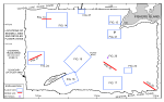 | Figure 12. Map showing the boundary of the acoustic data from NOAA survey H11250 and locations of the detailed planar views of the multibeam DTM and the seismic lines shown in other figures. Planar views and seismic lines are labeled with their respective figure numbers.
|
 | Figure 13. Chirp high-resolution seismic-reflection profile of the bedrock surface in the northwestern part of the study area. Note the glaciolacustrine sediments preserved in isolated lows. Location of profile is shown in figure 12. |
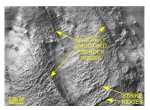 | Figure 14. Detailed planar view of the multibeam DTM showing the exposed bedrock surface in the northwestern part of the study area. Glacially-smoothed bedrock ridges parallel similar features and glacial striations onshore (Goldsmith, 1962); strike ridges parallel those of the onshore Avalon Terrane. Location of view is shown in figure 12. |
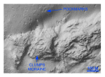 | Figure 15. Detailed planar view of the multibeam DTM showing the bouldery surface of the Clumps moraine. Circular to oblate depressions to the north are interpreted to be pockmarks that formed during the escape of biogenic methane and modified by modern tidal currents. Location of view is shown in figure 12. |
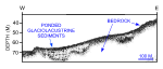
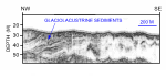 | Figure 16. Chirp high-resolution seismic-reflection profile showing the layered appearance of fine-grained glaciolacustrine sediments east Valiant Rock. Location of profile is shown in figure 12. |
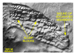 | Figure 17. Detailed planar view of the multibeam DTM showing mass wasting of glaciolacustrine sediments southeast of Valiant Rock. Note the large slump blocks of cohesive sediment and pile of excavated sediment. Location of view is shown in figure 12. |
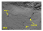 | Figure 18. Detailed planar view of the multibeam DTM showing sinuous hummocky ridge interpreted to be an esker, and conical mound interpreted to be a kame. Location of view is shown in figure 12. |
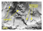 | Figure 19. Detailed planar view of the multibeam DTM showing wedge-shaped erosional outliers of coastal-plain strata present west-southwest of Valiant Rock. Location of view is shown in figure 12. |
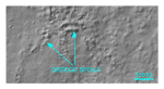
 | Figure 20. Detailed planar views of the multibeam DTM showing the wreck of the Volund, a steamer that sank in 1908 (Kimball, 2003), located immediately southeast of Valiant Rock. Note intense scour, suggesting net sediment transport to the west. Location of view is shown in figure 12. |
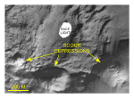 | Figure 21. Detailed planar view of the multibeam DTM showing circular point-associated scour depressions, presumably formed by strong eddies off Race Point. Location of view is shown in figure 12. |
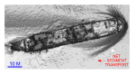
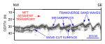 | Figure 22. Chirp high-resolution seismic-reflection profile showing large transverse sand waves southeast of Valiant Rock. Asymmetry shows net sediment transport is toward the east; megaripples on sand waves suggest that transport is active. Location of profile is shown in figure 12. |
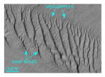 | Figure 23. Detailed planar view of the multibeam DTM showing transverse sand waves and megaripples southeast of Valiant Rock. |
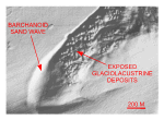 | Figure 24. Detailed planar view of the multibeam DTM showing a barchanoid sand wave northwest of Great Gull Island. Sand wave asymmetry indicates net transport there is to the east. Location of view is shown in figure 12. |
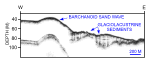 | Figure 25. Chirp high-resolution seismic-reflection profile showing a transect through a barchanoid sand wave northwest of Valiant Rock that is prograding over glaciolacustrine sediments. Interpretations are partly based on planar morphologies in the DTM. Location of seismic profile is shown in figure 12. |
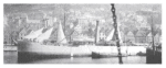 | Figure 26. Picture of the Volund, a steamer that sank in 1908 (Kimball, 2003).
|
 | Figure 27. Detailed planar view of the multibeam DTM showing the New London dump site with mounded dredge spoils. Location of view is shown in figure 12.
|


